Choose your language:
Equatorial Guinea
Geography
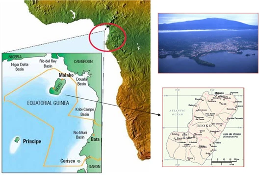
The Republic of Equatorial Guinea is located in Western Africa, bordering the Bight of Biafra, between Cameroon and Gabon. It is one of the smallest countries in continental Africa, and comprised of two main regions: a Continental Region (Río Muni) and an Insular Region (Bioko and Annobon), where the capital Malabo is situated. Included in Rio Muni are the small islands of Corisco, Elobey Grande, Elobey Chico, Mbañe, Cocoteros and the numerous small islets in Corisco Bay.

Climate
The climate of both the continental region and the islands is typically equatorial, with high temperatures, heavy rainfall, and cloud cover most of the year. Local variations are due to differences in altitude and proximity to the sea.
Equatorial Guinea Statistics
Population: 1.558.160 (2022)
Population Growth Rate: ~2% per year
Languages: Spanish, French, Portuguese (Official Languages); Fang, Bubi, Ndowe, Annobones and Bissio
Country Area: 28,051 sq km (10,830 sq mi)
Currency: CFA (Communaute Financiere Africaine)
Main Trading Partners: U.S.A., Spain, France, China, Cameroon, Gabon and UK
Source: I.N.E.G.E – The National Statistics Institute of Equatorial Guinea - www.inege.gq
Source: I.N.E.G.E – The National Statistics Institute of Equatorial Guinea - www.inege.gq

Copyright © Atlantic Methanol 2025
Multilingual website by Tribal Systems
